
Understanding FEMA Flood Zones
When certifying flood insurance requirements, it’s crucial to have clarity on the FEMA Flood Zones. In this post we offer some important base knowledge, a breakdown of the FEMA Flood Zones and what they mean, and how they are easily recognized by color shading on our Flood Zone Determination Reports.

What are Flood Zones?
The Federal Emergency Management Agency (FEMA) uses flood zones to identify areas according to their varying flood risk levels, from low to moderate to high risk and in-between.
FEMA Flood Insurance Rate Maps (FIRMs) show the boundaries of each flood zone, which dictates a property’s (or, more importantly, a structure’s) flood status and flood insurance requirements according to the National Flood Insurance Program (NFIP).
It’s important to note, NFIP mapping started in 1968 and was performed through the ‘70’s - nearly 50 years ago! Because land, development and environment changes over time, and also because of limitations to the original studies and mapping efforts, the zones and FEMA maps have and will continue to change over time. There may be many variables that contribute to a structure’s flood status, making it possible for Flood Zone designation - and, therefore, flood insurance requirements - to be potentially challenged, amended or changed.

Everyone is in a Flood Zone, Not Everyone is in a Special Flood Hazard Area.
Every property is mapped within a flood zone of some kind. Everyone lives in an area with some flood risk—it’s just a question of what level of risk is present. The different zones illustrate whether you live in a high-risk, low-risk, or moderate-risk flood zone.
Some important points and definitions to know:
A Flood Zone is any zone delineated on a FEMA Flood Insurance Rate Map (FIRM)
A Special Flood Hazard Area (SFHA) is a high risk flood zone, and is the land area covered by the base flood on a FIRM. This is where flood insurance may be required depending on structure location.
Sometimes the SFHA is casually referred to as the “Flood Zone”, but these terms shouldn’t be confused. All SFHA’s are flood zones, not all flood zones are SFHA's.
Base Flood is the area where flood has a 1% chance of being equaled or exceeded in any given year. Often referred to as the “100-Year Flood”, which frequently causes confusion.
Base Flood Elevation is the elevation, above sea level, at which Base Flood will inundate.

In this image, you can see how there is a lot more detail in the AE (red) area, compared to more widespread shading and less data in the A (pink) area, as described below. Learn more.
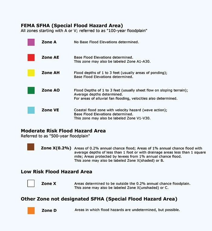
FEMA Flood Zone Descriptions
SFHAs
Zone A: Approximate Zone, no Base Flood Elevation (BFE) determined.
Zone AE (Old A1-A30): Detailed study, BFE determined.
Zone AH: Flood Depths of 1-3 feet (areas of ponding), usually shallow flooding. BFE determined.
Zone AO: Flood Depths of 1-3 feet (ares of sheet flow on sloping terrain). Average depths determined. For areas of alluvial fan flooding, velocities also determined.
Zone VE (Old V1-V30): Coastal flood zone with velocity hazard (wave action) BFE determined.
Non-SFHAs
Zone X (Old C): Areas determined to be outside the 0.2% annual chance floodplain. Low-moderate flood risk.
Zone X 0.2% (Old B): Areas of 0.2% annual chance of flood. Moderate flood risk. Also known as “X (shaded)” or “500-year floodplain”.
WTG Report Key
WTG Flood Zone Determination Reports utilize a combination of superior data and expert analysis to help lenders, investors and real estate professionals confirm or challenge official flood zone status, thereby challenging and potentially removing flood insurance requirements on properties secured with federally backed loans.
Each report has clear mapping detail that shows the pinpoint-accurate structure location as it exists on FEMA’s map, with a clear overlay of color-coded Flood Zones.
Questions?
The full support of our expert team comes with every WTG report.
If a structure is found to be in a Special Flood Hazard Area, requiring mandatory flood insurance, our team can advise on any potential options for challenging your flood status, and provide guidance in next steps.
If you have questions about your WTG report, or would like to explore the potential to challenge an official flood zone status, simply Contact Us and provide your report order number.
WTG is a flood zone determination company. We do not provide flood insurance. Please consult with a flood insurance agent to understand flood insurance premium options. The information provided is for informative purposes only and is not intended to be legal advice or a legal opinion. For legal advice, please consult an attorney.